US-62 trunk relocation Muskogee
ODOT MOT — permit calendar before rig.
Muskogee, OK · Muskogee County
Muskogee Arkansas and Verdigris crossings — long-span HDD when open cut fails ODOT and floodplain review on US-62 river frontage.
US-62 through Muskogee defaults trenchless for trunk relocations — ODOT MOT and permit lead often exceed bore duration on alluvium approaches.
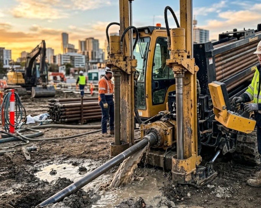
Directional boring at river crossing scale means larger spreads and flood-window planning months ahead on eastern Oklahoma pulls.
Arkansas and Verdigris outfalls add environmental awareness — wet bank trench versus HDD scoped per alignment and season.
Rail spurs near port industrial carry owner agreements — same trenchless logic when restoration would retrench plant access roads.
Real Muskogee County angles — not generic statewide copy.
ODOT MOT — permit calendar before rig.
HDD versus wet bank trench after flood season.
Floodplain per alignment — environmental scoped in quote.
City MOT on commercial corridor with alluvium pit contingency.
ODOT or city permit leads beyond 811. Larger rigs, as-builts, and MOT windows on US-62. River crossings checked against floodplain notes on plan.
Muskogee County river alluvium, sandstone, and claystone with sandy Verdigris bottoms — groundwater and variable bearing unlike red-clay OKC profiles.
Muskogee bores encounter Arkansas and Verdigris river alluvium with sandstone and claystone on higher benches — penetration changes quickly on port industrial approaches and Three Forks lowlands. Groundwater near river bottoms raises buoyancy risk on long HDPE pulls. East toward the county line, tighter claystone can slow penetration without correct bit selection.
Arkansas River valley humidity and spring flood stages — post-storm saturated banks soften Three Forks approaches; summer heat on long US-62 pulls.
Spring flood stages on the Arkansas and Verdigris are Muskogee's biggest calendar variables — saturated banks delay entry work. Summer heat affects long US-62 pulls. Lightning holds stop rigs during severe weather. We plan bore windows around known wet seasons rather than risk frac-out into the water table.
City of Muskogee Engineering, Muskogee County ROW, ODOT on US-62 and US-69, Arkansas River floodplain rules on select routes.
City of Muskogee permits street and drive work inside limits. Muskogee County ROW on rural US-62 and US-69 approaches. ODOT controls state highway bores. Arkansas River and Verdigris floodplain work may need environmental review — scoped per alignment, not assumed.
Arkansas River and US-62 floodplain crossings rarely justify open cut — MOT, environmental, and restoration math favors HDD.
Length, diameter, groundwater, environmental windows, flagging, engineering, inspection.
You share plans or describe the problem; we confirm alignment, depth, access, and which trenchless method fits Oklahoma soils.
Oklahoma One-Call ticket filed; two business days minimum before pits open unless your permit path differs. We pothole where marks conflict.
Bore plan, ODOT or city ROW permits, railroad agreements, and crossing engineering when the path leaves private property.
Compact spread for tight Edmond lots; larger HDD for I-35 or I-40 relocations — matched to length and diameter.
Steered pilot on design line, ream passes sized for your pipe or casing, fluid program tuned for clay or sand lenses.
HDPE fusion, steel casing, or multi-duct bundle pulled with tension and bend-radius monitoring.
Pressure test, mandrel, or survey records for owners, inspectors, and operators as spec requires.
Compact pits, replace sod or hardscape per scope, leave 811 ticket and locate map in your project file.
Weeks to months before drill — scoped in engineered quote.
Engineered dividers per ODOT or owner spec.
Alignment and season drive method — flood stages shift risk.
Owner or railroad agreements set path and flagging.
Engineered — length, groundwater, MOT, and permit drivers listed in quote.
24/7 — Emergency dispatch statewide. Tell us entry, exit, pipe size, and county — a bore specialist calls back with cost drivers, not a flat rate.
Scope your bore path
Step 1 of 2 — path, pipe, and city first